
Neighbourhood Guide · Malton
Malton: Homes 38% Below the City Average, and What the Airport Tradeoff Costs You
Malton sits directly beside Pearson International Airport, and that proximity is the single biggest reason its homes sell well below the Mississauga average. The math is real — but so is the noise, the industrial neighbours, and a job market built on warehousing and logistics rather than office towers. Here's the honest cost-of-living picture for L4T.
Malton is bounded roughly by Highway 427, Finch Avenue, and the Etobicoke border in Mississauga's northeast corner, with Toronto Pearson International Airport sitting partially inside its boundary. The neighbourhood developed through the 1960s and 70s around aviation and manufacturing employment — de Havilland Canada (later Bombardier/de Havilland Aircraft of Canada) has operated a major plant here for decades — and that industrial backbone still shapes Malton's economy today: warehousing, logistics, air cargo, and light manufacturing dominate the local job base far more than the office and retail employment found in City Centre or Erin Mills.
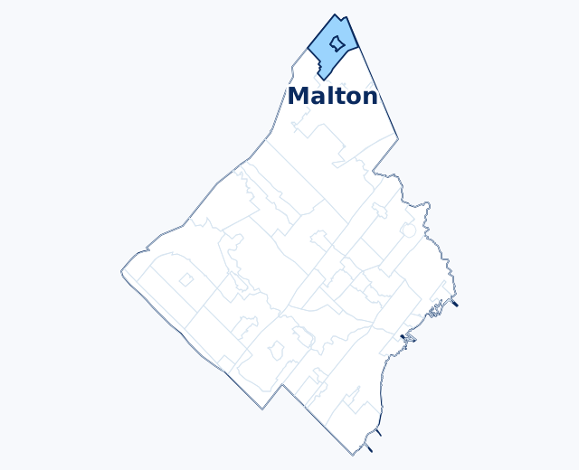
That industrial character is a big part of why Malton’s homes sell well below the city average. Zolo’s figures, read 14 September 2026, put Malton’s average listing price at $731,000, about 38% below Mississauga’s $1,188,000, with townhouses listing at an average of $739,000 and homes sold over the preceding 56 days averaging $768,981. Zolo names condo-heavy City Centre ($581,000), not Malton, as the city’s most affordable neighbourhood. The Property Tax 2026 ward breakdown also places Malton’s typical MPAC assessed range ($350K–$580K) at the bottom tier of all 11 Mississauga wards. For a buyer priced out of Streetsville or Port Credit, Malton is one of the few remaining entry points into Mississauga home ownership under $850K.
| Neighbourhood | 1-Bed Apt / mo | Avg. Listing Price | Transit Access |
|---|---|---|---|
| Malton | $1,799 | ~$731K | Malton GO — on-site, Kitchener line |
| Cooksville | $1,848 | ~$1.11M | Cooksville GO + future LRT |
| Churchill Meadows | $2,097 | ~$1.09M | MiWay only — no GO station |
| Streetsville | $2,150 | ~$1.19M | Streetsville GO — on-site |
| Mississauga (city-wide) | $2,027 | ~$1.19M | Varies |
Sources: Zumper rent research for Malton, Cooksville, Churchill Meadows, Streetsville and Mississauga, 1-bedroom medians read 14 September 2026; average listing prices from Zolo, read 14 September 2026. Malton’s all-unit median has swung between readings: $2,564 in mid-August, $2,400 on 26 August and $2,471 on 14 September 2026.
What shapes the cost of living in Malton
- Postal code L4T covers Malton and the portion of Toronto Pearson International Airport that sits within Mississauga's boundary
- Malton GO Station offers direct service on the Kitchener line — a genuine transit asset that doesn't carry the price premium seen in Streetsville or Port Credit
- Average listing price about $731,000, roughly 38% below the Mississauga average of $1,188,000; homes sold over the 56 days to 10 September averaged $768,981 (Zolo, 14 September 2026)
- Ward 5 (Britannia Woods & Malton) has the lowest typical MPAC assessed range of the city's 11 wards — $350K–$580K — which directly lowers the annual property tax bill
- About 77% of Malton households own and 23% rent; median rent across all unit types read $2,471/month on 14 September 2026, above the citywide figure despite much lower home prices, a gap worth factoring into a buy-vs-rent decision
- Employment base is concentrated in aviation, logistics, warehousing, and light manufacturing rather than office or retail — de Havilland Canada's aircraft plant has operated in the neighbourhood for decades
- Proximity to Pearson means real, documented noise and air quality tradeoffs in parts of the neighbourhood closest to runways and cargo facilities — factor this into any property visit, not just the listing price
- MPAC assessments remain based on Jan 1, 2016 values — in a lower-priced market like Malton's, this generally works in homeowners' favour relative to current resale values
Correction · Corrected 14 September 2026. This page previously stated that Malton has Mississauga’s most affordable housing stock and lowest home prices, gave its average sale price as $802,295, and put it about $180,000 below a city-wide average of $982,710. Zolo, read 14 September 2026, names City Centre as the city’s most affordable neighbourhood. On the same date Malton’s average listing price was $731,000, about 38% below the city’s $1,188,000, and its 56-day average sale was $768,981. The headline, figures and savings estimates were updated to match.